Gps Area Measurement
Gps Area Measurement Summary
Gps Area Measurement is a ad-supported, with in-app purchases Android app in Maps And Navigation by Cards. Released in May 2018 (7 years ago). It has about 3.2M+ installs and 5.2K ratings with a 3.42★ (mixed) average. Based on AppGoblin estimates, it reaches roughly 178.5K monthly active users and generates around $10K+ monthly revenue (72% IAP / 28% ads). Store metadata: updated Sep 23, 2025, version 71.
Recent activity: 128.1K installs this week (257.2K over 4 weeks) showing exceptional growth , and 1.00 new ratings this week View trends →
Data tracking: SDKs and third-party integrations were last analyzed on Feb 28, 2026. The app's network data flows (API traffic to/from the app and its SDKs) were last crawled on Oct 17, 2025.
Store info: Last updated on Google Play on Sep 23, 2025 (version 71).
Gps Area Measurement was last scanned for SDKs 2026-02-28. Below is the overview of third party companies detected in the app. The full list of raw SDKs, app permissions and unknown SDKs is available here.
3.42★
Ratings: 5.2K
Screenshots

App Description
Measure land areas quickly and accurately with GPS-based features.
GPS Area Measurement app or GPS land measurement is a smart tool app to calculate the field’s measurements directly from maps. Users have lots of options to calculate in units, feets, meter and miles. GPS Perimeter App is helping thousands of people in terms of measurement of lands & areas. Gps acreage calculator is a free area and land calculator superficial app. Gps Area Calculation app for land calculation directly from a map. Don't waste time & get this user friendly Gps Area Measurement App for Free.
Key Features
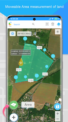
Area Measurement
Accurately calculate the size of any land or plot with user-friendly area measurement. Perfect for measuring fields, farms, construction sites, or landscaping projects, it provides precise acreage or square footage results for effective planning and management. GPS Land Area Calculator simplifies determining acreage, square footage, or any plot size with accuracy. Perfect for large fields, farms, construction sites, or land development projects, this calculator ensures quick and reliable results.
Acreage Calculator
Easily calculate acreage for large fields, farms, or land development projects and obtain accurate results for any plot of land.
Converter
Easily convert between different units of land areas, distance, weight, volume, energy, temperature, velocity and power, such as acres, square feet, square meters, hectares, and more. Converter simplifies land measurements by allowing you to switch seamlessly between units based on your project needs.
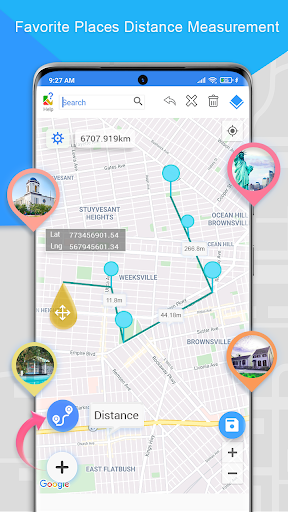
Distance Calculator
Easily measure the distance between two points on the map using the distance measure feature. Ideal for measuring fencing, roads, or pathways across your land.
Location
Location uses latitude and longitude to pinpoint exact locations on the Earth's surface. Latitude lines run horizontally and measure the distance north or south of the equator, while longitude lines run vertically and measure the distance east or west of the Prime Meridian. In GPS Area Measurement, these coordinates help accurately define and measure the boundaries of land or plots.
Compass
The compass feature helps you navigate and orient yourself accurately while measuring land areas. Using real-time GPS data, the compass detects your direction (North, South, East, or West) and guides you to mark points or boundaries with precision.
Bubble Level
The bubble level detects your