İBB E-Plan
İBB E-Plan Summary
İBB E-Plan is a mobile Android app in Maps And Navigation by İstanbul Büyükşehir Belediyesi. It has about 4K+ installs Based on AppGoblin estimates, it reaches roughly 259 monthly active users . Store metadata: updated Mar 4, 2024.
Recent activity: 24 installs this week (113 over 4 weeks) showing steady growth View trends →
Store info: Last updated on Google Play on Mar 4, 2024 .
0★
Ratings: 0
Screenshots


App Description
It enables Istanbul Development Plans to be queried and viewed.
Istanbul Metropolitan Municipality E-Plan application,
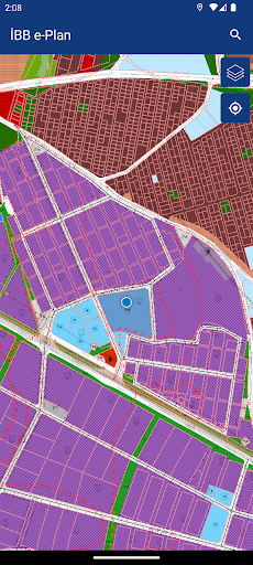
It is an application that allows Istanbul 1/5000 Master Development Plans to be queried and viewed on the map.
On the search screen of the application, the desired parcel can be found with address information or district/island/parcel information. In addition, inquiries can be made by selecting the parcel via the map application.
• The plan note for the parcel in question can be downloaded.
• E-plan information form can be created.
• The following information can be accessed about the queried parcel.
- 1/5000 scale Plan Function Information,
- Protected Areas,
- Basin Protection Areas,
- Disaster Risk Areas, Renewal Areas, Reserve Areas, Protected Areas, Privatization Areas, Organized Industrial Zones, Special Environmental Protection Zones, Tourism Areas, etc. areas where different institutions are authorized,
- Bosphorus Front View, Back View, Affected Areas,
- Coastal Edge Line,
- Disaster Exposed Area Borders,
- Special Project Area Limits
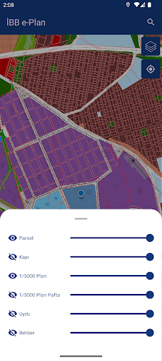
• The following layers can be added to the map with the layer management panel.
- 1/5000 scale Digital Plans,
- 1/5000 scale Raster Plans,
- 1/5000 scale Plan Modifications,
- Satellite image,
- Istanbul City Guide
• In the layer list section, the transparency of these layers can be increased or decreased and the added layer can be removed from the map.
• Parcel and Address searches can be performed.
• With the get information from location feature, plan information can be obtained from any location on the map.
• Opinions and suggestions regarding the application can be conveyed to the administration.
- Numerical data regarding 1/5000 scale master development plans were prepared by the IMM Planning Directorate.
- Since 1/5000 scale master development plans contain principle decisions, plan representations are schematic and measurements cannot be taken with the plan scale on the plan.
- Plan data published in this application is for informational purposes only and does not constitute an official document.