Hurricane & Typhoon Track
Hurricane & Typhoon Track Summary
Hurricane & Typhoon Track is a ad-supported Android app in Weather by H & Y Studio. Released in Mar 2018 (8 years ago). It has about 197.2K+ installs and 530 ratings with a 3.74★ (average) average. Based on AppGoblin estimates, it reaches roughly 10.7K monthly active users and generates around $<10K monthly revenue (0% IAP / 100% ads). Store metadata: updated Aug 13, 2025, version 123.
Recent activity: 7.3K installs this week (12.4K over 4 weeks) showing exceptional growth View trends →
Advertising: AppGoblin detected 1.00 monetized ad creatives shown inside the app.
Data tracking: SDKs and third-party integrations were last analyzed on Oct 29, 2025. The app's network data flows (API traffic to/from the app and its SDKs) were last crawled on Jun 20, 2025.
Store info: Last updated on Google Play on Aug 13, 2025 (version 123).
Hurricane & Typhoon Track was last scanned for SDKs 2025-10-29. Below is the overview of third party companies detected in the app. The full list of raw SDKs, app permissions and unknown SDKs is available here.
3.74★
Ratings: 530
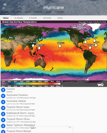
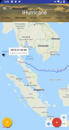
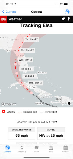
Screenshots

App Description
Track and forecast storm ,Typhoon and hurricane path in the Global Ocean
Hurricane & Typhoon Track allows you to keep track of tropical storm ,Typhoon,and hurricane activity in the Global Ocean basins. gives you the most up to the minute and reliable hurricane & Typhoon path,Tracking Map,coordinates data,Satellite Images, Computer Models,Warning Information and high resolution Satellite maps... with data provided by 22,000+ trusted or official weather stations all over the world.
Also, you will be able to stay informed on the status of the local and national power grid and surge probability.
Here are the key highlights of this application...
* Quick overview of active hurricanes, tropical storms, depressions, and other cyclones
* Get real-time Hurricane & Typhoon Tracking
* Emergency Shelters
* Tap on any map to view full screen, with pinch-to-zoom, drag, and scroll support, even during loop playback
* Current Storm Location
* Computer Models
* Forecast cones (5-day uncertainty track), wind speed probability, storm surge maps (when available), and GOES Floater satellite imagery
* Storm Surge Probability
* Optional Forecast Model Viewer Add-On: View forecast models (also known as spag models) for active systems on an interactive map complete with panning, zooming, and individual model point information when tapped. Features selectable models, start time, and run length
* Sharing of screenshots with any app that supports it (Facebook, Twitter, etc.)
* Multiple types of regional summary maps and satellite loops to choose from (full list below)
* Road Maps
* Historical Map
* Per-storm advisory & discussion text from the experts at the National Hurricane Center, Public & Marin Advisory
**************************************
all the data is just from National Oceanic and Atmospheric Administration, (NOAA)
Stay informed about the latest tropical systems in the Atlantic,Pacific,Indian Ocean and Caribbean . Get the most recent maps and forecast details about active storms.